|
MapCatalog | Order | Support | SiteIndex | Contact | Home | ||||||||||
|
|
|
|
|
|
|
|||||||||||
| MH Maps | Tech Spec | Download | License | Showcase | Reviews | |||||||||||
|
MapCatalog | Order | Support | SiteIndex | Contact | Home | ||||||||||
|
|
|
|
|
|
|
|||||||||||
| MH Maps | Tech Spec | Download | License | Showcase | Reviews | |||||||||||

Technical Specs |
MHM en Francais |
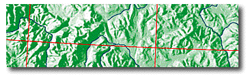
MOUNTAIN HIGH MAPS is a one-of-a-kind collection of relief images of our world's continents, countries, and ocean floors. Each dimension and contour of our splendid planet is portrayed in a meticulously detailed and accurate topographical relief view. These images can be used to lend a fascinating realism to your print, video, or multimedia projects, putting the whole world right in your hands to help you get your message across.
The ultimate map making resource
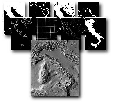
MOUNTAIN HIGH MAPS is published as a four-disc CD-ROM set for either Windows or Macintosh computers. Each set contains 78 maps, available in three colorized formats - physical elevation, physical vegetation, political, and in grayscale, with and without ocean floors, along with 39 global views - giving you, with colorized and animated versions, more than 540 map images to choose from. Each map comes complete with outlines, borders, country names, rivers, cities and towns, physical features, linear scales, and lines of latitude and longitude in both Freehand & Illustrator EPS formats, JPEG paths and TIFF masks.
Accurate and detailed maps
MOUNTAIN HIGH MAPS is the result of 20 years of intense research and highly skilled map modeling. Each relief model was constructed from intricate survey data to recreate exacting land and ocean contours. The models were lit from strategic cardinal points and photographed to provide superior and more striking views than comparable satellite images. Each image was computer engineered with the highest quality scanners and image editors to retain the integrity of the original models.
A revolutionary World view
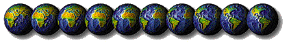
Many spectacular perspectives of the globe are available in the MOUNTAIN HIGH MAPS collection in greyscale(with land/ocean masks) and colorized versions. These include regional views from high-interest areas of the world, global versions from strategic points, plus perspectives which are centered on major locations such as London, Moscow, Chicago and Dubai. A set of 38 animated revolving globes are also included for you to use in your multimedia projects.
Flexible applications
The maps are presented both as high resolution image files for the highest quality reproduction, and low resolution files for use with laser output or multimedia applications. The high-resolution versions are typically 2250 x 2600 pixels, making them suitable for output by imagesetter to fine halftone screen rulings. MOUNTAIN HIGH MAPS are provided in colorized formats and grayscale images, giving you the ability to apply your choice of colors through a wide range of the most popular DTP applications. Each CD-ROM set comes with up-to-the-minute tips on how to best utilize your maps with these programs. The colorized and grayscale maps are in the industry standard TIFF and JPEG format, and can be used by most paint, draw, and page layout applications, and many word-processing programs.
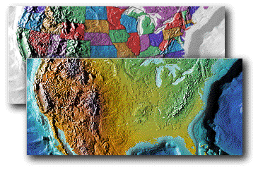
This colorful world
Although the maps are grayscale, the MOUNTAIN HIGH MAPS set also includes a selection of expertly colorized maps both in physical and political color schemes.
Easy to use
All maps are referenced in an extensive catalog which is included with each CD-ROM set. MOUNTAIN HIGH MAPS also includes a map catalog viewing application which provides you with a quick and easy way to find and display the exact map you wish to illustrate. The viewing application also contains important information, such as precise perimeter coordinates, projection details, vertical scale related to horizontal scale, original contour increments, file size (original and if converted to RGB, CMYK, and EPS modes), and image dimensions.
A new world for your maps
MOUNTAIN HIGH MAPS is a unique and uncomplicated way to dramatically enhance your map presentations. Used as backgrounds for your artwork and data, these maps will give your images a new authority and impact, whether your needs are for the highest level of professional cartography, television broadcasts, multimedia or web authoring, advertising, book and magazine publishing or merely for laser output as part of a report. Reproduction rights granted with your purchase of MOUNTAIN HIGH MAPS allow internal use and, with free registration, almost unlimited commercial use without further payment of fees - MOUNTAIN HIGH MAPS can be freely used for most commercial purposes, subject to the conditions of the License Agreement shipped with each set.
Award winning product
MOUNTAIN HIGH MAPS Version 2.1 was honored with the MacUser Editors' Choice "EDDY" Award for "Best New Graphics Resource". Digital Wisdom was presented with this prestigious award in San Francisco Macworld Expo in January by MacUser magazine's editor-in-chief, Pamela Pfiffner.
Request literature
If you like to have our Mountain High Maps literature package mailed to you, please click here for details.
Upgrade to Version 4.0
Preferential terms are available to existing owners of MOUNTAIN HIGH MAPS versions 1.0, 2.0 and 2.1. Check our upgrade page for details.
© Digital Wisdom, Inc.